


Latest Version
Version
Latest
Latest
Update
June 18, 2026
June 18, 2026
Developer
SWM-Soft
SWM-Soft
Categories
Platforms
Android
Android
Downloads
0
0
License
Free
Free
Package Name
gpxexplorer.swmsoft.de
gpxexplorer.swmsoft.de
Report
Report a Problem
Report a Problem
More About GPX Explorer Hiking & Bike GPS
🌍 GPS NAVIGATION, OFFLINE MAPS AND GPX VIEWER FOR YOUR OUTDOOR ADVENTURES
Want to open a GPX file and hit the trail immediately? Import your routes in seconds and navigate safely with top-tier topographical offline maps. Perfect for planning walks along public footpaths, downloading trails for national park or long-distance hikes, and turning your smartphone into a reliable bike computer and hiking GPS.
As a powerful GPX viewer and GPS tracker, GPX Explorer is the ultimate tool for hiking, walking, cycling, mountain biking (MTB), trekking, and bikepacking.
🗺️ RELIABLE GPS NAVIGATION & PUBLIC FOOTPATHS
• Real-time Location: Track your exact GPS position instantly on the interactive outdoor map.
• Perfect for UK Trails: Follow public footpaths, bridleways, and National Trails with highly detailed, crisp map layers.
• Off-track Alerts: Never get lost in the mist or open moors. Receive instant notifications the moment you deviate from your planned route.
• Global Offline Maps: Download maps in advance and navigate safely in the hills, completely without cellular signal or internet connection.
• Topographical Layers: Access detailed cycle tracks, contours, and MTB trails (OpenCycleMap / OpenStreetMap).
📂 OPEN, IMPORT & MANAGE GPX FILES
• Open All Formats: Seamlessly import tracks, routes, and waypoints from GPX, KML, KMZ, TCX, and GeoJSON files (perfect for files from popular UK walking portals).
• Add Custom Waypoints: Mark and save important points of interest (POIs) like campsites, water sources, or scenic viewpoints directly on the map.
• Clean Folder Structure: Keep your imported routes organized by region (e.g., mountainous regions, coastal routes) or activity.
✏️ GPS TRACKER: RECORD YOUR OWN WALKS & RIDES
• Save as Standard GPX: Track your hikes and bike rides continuously without interruption, ready for export or sharing.
• Efficient Background Tracking: The GPS signal remains stable and accurate, even when your screen is turned off and the phone is in your pocket.
• Unlimited Track Storage: Store and manage your custom tracks, waypoints, and routes (some extended management features may require an optional in-app purchase).
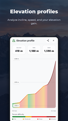
📊 ELEVATION PROFILES AND REAL-TIME STATISTICS
• Live Data Tracking: Analyze distance, current speed, elevation gain, and remaining miles in real time while moving.
• Accurate Elevation Profiles: Monitor upcoming steep climbs and hills to pace yourself perfectly along the route.
• Bike Computer View: A clean dashboard layout that serves as a perfect handlebar display for cycling and mountain biking.
🔋 MAXIMUM BATTERY LIFE FOR LONG DAYS OUT (PREMIUM)
• Battery Saver Mode for GPS: Our optimized algorithms drastically reduce smartphone power consumption—essential for cold days on the hills.
• Multi-day Treks: Ideal for backpacking trips and wilderness expeditions where daily charging isn't an option.
Turn your smartphone into a high-performance GPS partner for the great outdoors. Download GPX Explorer and start your next route today!
Want to open a GPX file and hit the trail immediately? Import your routes in seconds and navigate safely with top-tier topographical offline maps. Perfect for planning walks along public footpaths, downloading trails for national park or long-distance hikes, and turning your smartphone into a reliable bike computer and hiking GPS.
As a powerful GPX viewer and GPS tracker, GPX Explorer is the ultimate tool for hiking, walking, cycling, mountain biking (MTB), trekking, and bikepacking.
🗺️ RELIABLE GPS NAVIGATION & PUBLIC FOOTPATHS
• Real-time Location: Track your exact GPS position instantly on the interactive outdoor map.
• Perfect for UK Trails: Follow public footpaths, bridleways, and National Trails with highly detailed, crisp map layers.
• Off-track Alerts: Never get lost in the mist or open moors. Receive instant notifications the moment you deviate from your planned route.
• Global Offline Maps: Download maps in advance and navigate safely in the hills, completely without cellular signal or internet connection.
• Topographical Layers: Access detailed cycle tracks, contours, and MTB trails (OpenCycleMap / OpenStreetMap).
📂 OPEN, IMPORT & MANAGE GPX FILES
• Open All Formats: Seamlessly import tracks, routes, and waypoints from GPX, KML, KMZ, TCX, and GeoJSON files (perfect for files from popular UK walking portals).
• Add Custom Waypoints: Mark and save important points of interest (POIs) like campsites, water sources, or scenic viewpoints directly on the map.
• Clean Folder Structure: Keep your imported routes organized by region (e.g., mountainous regions, coastal routes) or activity.
✏️ GPS TRACKER: RECORD YOUR OWN WALKS & RIDES
• Save as Standard GPX: Track your hikes and bike rides continuously without interruption, ready for export or sharing.
• Efficient Background Tracking: The GPS signal remains stable and accurate, even when your screen is turned off and the phone is in your pocket.
• Unlimited Track Storage: Store and manage your custom tracks, waypoints, and routes (some extended management features may require an optional in-app purchase).
📊 ELEVATION PROFILES AND REAL-TIME STATISTICS
• Live Data Tracking: Analyze distance, current speed, elevation gain, and remaining miles in real time while moving.
• Accurate Elevation Profiles: Monitor upcoming steep climbs and hills to pace yourself perfectly along the route.
• Bike Computer View: A clean dashboard layout that serves as a perfect handlebar display for cycling and mountain biking.
🔋 MAXIMUM BATTERY LIFE FOR LONG DAYS OUT (PREMIUM)
• Battery Saver Mode for GPS: Our optimized algorithms drastically reduce smartphone power consumption—essential for cold days on the hills.
• Multi-day Treks: Ideal for backpacking trips and wilderness expeditions where daily charging isn't an option.
Turn your smartphone into a high-performance GPS partner for the great outdoors. Download GPX Explorer and start your next route today!
Rate the App
Add Comment & Review
User Reviews
Based on 0 reviews
No reviews added yet.
Comments will not be approved to be posted if they are SPAM, abusive, off-topic, use profanity, contain a personal attack, or promote hate of any kind.
More »

Popular Apps

Dawn of Zombies: Survival GameRoyal Ark

Network Data SubIsah

Tank Force: War games of BlitzXDEVS LTD

Grim Soul: Dark Survival RPGBrickworks Games Ltd

Kaspersky: VPN & AntivirusKaspersky ME

WhatsApp MessengerWhatsApp LLC

NordVPN – fast VPN for privacyNord Security

Kaspersky Fast Secure VPNKaspersky ME

Call of Duty Mobile Season 8Activision Publishing, Inc.

Vikings: War of ClansPlarium LLC
More »
Editor's Choice
Grim Soul: Dark Survival RPGBrickworks Games Ltd

Craft of Survival - Gladiators101XP LIMITED

Last Shelter: SurvivalLong Tech Network Limited
Dawn of Zombies: Survival GameRoyal Ark

Merge Survival : WastelandStickyHands Inc.

AoD Vikings: Valhalla GameRoboBot Studio

Viking Clan: RagnarokKano Games
Vikings: War of ClansPlarium LLC

Asphalt 9: LegendsGameloft SE

Modern Tanks: War Tank GamesXDEVS LTD